I’m thrilled that Daniel Cruger has started up a blog, Tales from the Tower, where one can find many of the excellent layouts (cities, fortresses, and similar things) that Dan did for ICE’s Middle-earth line of products during the 1990s.
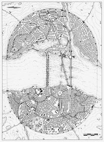
Below is the layout for the city Osgiliath from the magnificent Kin-Strife campaign module (published in 1995).

Many other layouts from the Kin-Strife can be found here.
Not only are these layouts great for Middle-earth campaigns, but they could easily be used with other fantasy settings as well.
I’m looking forward to future posts of Dan’s work over at Tales from the Tower!

Wow, that's beautiful. I never owned Kin-Strife but wish I did. Thanks for the link.
ReplyDeleteThose MERP sourcebooks were filled with beautiful maps, in a number of different styles. Nice to see him sharing these out.
ReplyDeleteThis comment has been removed by the author.
ReplyDeleteThanks for the compliments. I plan on posting more maps once a week until most of the modules I worked on have been represented. I'm doing this for two reasons - first to create an online portfolio of my work and second so that GMs can use them in their games. I own the artwork and rights to it but know these will be posted all over the internet. I only ask that people don't publish them without contacting me first.
ReplyDeleteWhen I said publish, I meant in a book or PDF for sale. I have no problem with people copying them and posting them on blogs or wherever (like this post) as long as they don't claim the layouts as their own work.
ReplyDeleteI love how it's clear from the pylons which way the river flows. But is this map a version without text? Because I want to know which way is north and how far each of those measurement units is.
ReplyDeleteYeah, these are the pre-press layouts. ICE added the text when they did the page layout. The CAD images have room numbers, scale info and north on them but not the hand drawn ones. North is to the left - look at the plan for the Tower dome (next layout down on the blog) and compare it to the plan of the tower dome on the bridge (upper middle right hand corner of map) and you can see which way is north.
ReplyDeleteI may end up posting layouts with the module text later but for now these scans are what they are. As a GM you can add text as necessary if you plan on using them in your game.